Public Release Notice: Nonpoint Source Watershed Projects Data Explorer
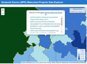
The United States Environmental Protection Agency (EPA) and New Hampshire Department of Environmental Services Nonpoint Source Management Programs are excited to announce the release of an enhanced web mapping application to explore the Nation’s nonpoint source (NPS) watershed projects. It houses information on where NPS projects are being implemented, how CWA §319 Grant funds are used, and progress toward meeting pollution reduction goals. The Data Explorer is a useful tool for interested community members, local watershed partners, and other non-governmental stakeholders to understand the work being done in their watersheds to restore and protect water quality. Enhanced features include a dynamic map with integrated reports that update based on the map view, data filters to narrow search criteria to focus results, and customizable reports for download. The application also integrates NPS program information with other EPA data systems, such as How’s My Waterway, for integrated watershed management. To explore the nonpoint source projects with the interactive map and integrated reports, click here.