Once the field data has been collected and reviewed for Quality Assurance and Quality Control by NHDES, the data is run through a series of models to assign scores to the stream crossings for 1) Geomorphic Compatibility, 2) Aquatic Organism Passage, 3) Hydraulic Vulnerability, and 4) Asset Condition. Different agencies and watershed groups can determine how they want to use these scores to prioritize crossing replacements and repairs.
Geomorphic Compatibility
The Geomorphic Compatibility (GC) score evaluates how well the stream crossing structure fits within the natural shape and form of the stream and whether it alters water and sediment transport. This is completed to predict the long-term compatibility of a stream crossing with river channel form. The GC score is derived from a model that uses the survey data to rank the crossings from “fully compatible” to “fully incompatible”.
Several key parameters factor into the GC score:
- Size of Structure Relative to the Stream Channel: The ratio of structure width to the average reference bankfull width of the stream shows if the crossing is undersized for the water flows coming into it from upstream.
- Sediment Continuity: Indicators that the structure is inhibiting natural sediment transport include upstream sediment deposits accumulating at the inlet, scour around the structure at the inlet, outlet, and the streambed.
- Bank Stability: Signs that there is bank erosion occurring from high velocity water moving through the site include collapsing banks, exposed soils, deep, undercut banks, and trees falling over with exposed roots.
- Stream Angle: The approach angle of the stream as it enters the structure is critical to how water and sediment will move through the crossing, and situations where the culvert is installed at a mild to sharp angle will lead to bank erosion on the outer bend and deposition at the inlet.
- Slope: Crossings that are installed either steeper or flatter than the natural channel slope will negatively affect how water and sediment moves through the stream.
- Wetland and Surface Water Crossings: Because these systems do not have channelized, flowing water, the GC score does not apply and they are flagged by the upstream waterbody type. These waterbodies are often important habitats for fish and wildlife, so they still receive a score for Aquatic Organism Passage.
Read the Geomorphic Compatibility handout to learn more!
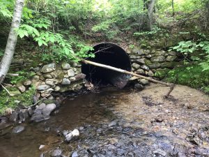
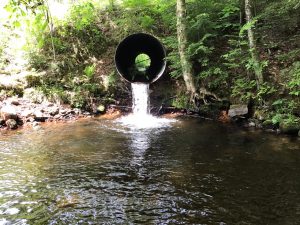
This stream crossing has a sharp bend approach angle and a defined side bar at the inlet (left), both red flags for geomorphic compatibility. Now at the outlet of that crossing (right) we see the structure slope is lower than the channel slope and the perched structure is providing a barrier to AOP.
Aquatic Organism Passage
The Aquatic Organism Passage (AOP) score is used to identify crossings that may be barriers to aquatic organisms and prohibit their movements through the stream.
The AOP score is assigned from multiple parameters collected in the field:
- Obstructions: Screens, debris, wood, and sediment that block the inlet or outlet will prevent animal passage through the structure.
- Sediment Continuity: Aquatic animals need natural sediment to move through that creates small pockets of lower velocity water. A structure with an exposed bottom and lack of substrate reduces the ability for fish and other animals to move through.
- Outlet Water Profile: The way in which the water flows through and out of the crossing greatly affects the ability of fish and wildlife to move up through the structure. type is collected to better understand the outfall characteristics of a crossing. The vertical distance, called outlet drop, from the outlet to the downstream water surface, is used to assess whether a structure is a full, reduced, or complete barrier to AOP.
- Water Depth within the Crossing and Directly Downstream: Some fish that are strong swimmers, such as brook trout, are able to jump up to a certain height, only if there is adequate water depths within and downstream of the outlet for the fish to swim through.
Read the AOP handout to learn more!
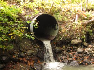
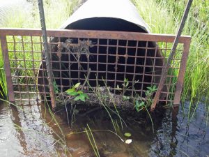
Sometimes screens are placed across the inlet of a crossing to prevent debris from getting lodged inside (right photo). These screens are a complete barrier to aquatic organisms and often trap sediment and vegetation, causing water to pond at the inlet. When a culvert is undersized, the high velocity water exiting the pipe can scour away the downstream channel, causing the outlet to become perched over time (left photo). This type of outlet is impassable by all fish and wildlife trying to move upstream.
Hydraulic Vulnerability
The hydraulic capacity score predicts how a stream crossing will transport flows during storm events. This information is helpful to make mindful decisions on flood probability prediction and identifying the most vulnerable infrastructure.
The hydraulic model uses several parameters collected in the field and GIS-based analyses:
- Streambed and Roadway Elevations: Are measured in the field, and are used to help characterize the geometry and capacity of the stream crossing relative to expected water levels during storms.
- Inlet and Wingwall Types: The angle of the wingwalls and the orientation of the inlet influence how water enters the structure.
- Structure Material, Dimensions, and Slope: These characteristics of a crossing will influence the quantity and velocity of water moving through the crossing and whether water will accumulate at the inlet.
- Hydrological Equations: Regional hydrologic curves are used to predict stream flows to estimate the amount of water coming into a crossing for a 5, 10, 50 and 100-year flood event.
- Watershed Characteristics: A GIS-based analysis provides information on the landcover types and soils of the watershed that drains into the crossing.
Read the Hydraulic Vulnerability handout to learn more!
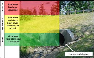
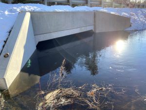
A visual representation of the predicted water levels at a crossing from the model (left photo) and a box culvert that is able to pass flows for a 50-year storm event.
Infrastructure Condition
The structure condition score is based upon a visual assessment of the the interior walls, surfaces, and bottom of the conduit that passes the water. The wingwalls and headwall are also assessed at the inlet and outlet, separately. This score is crucial to determining the structural integrity of a crossing and whether it can withstand the normal wear and tear of passing water, sediment, and wood downstream. 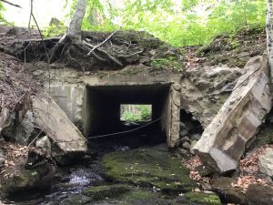
Good: Like new, with little or no deterioration, consistent shape, minor joint misalignment, no movement, structurally sound and functionally adequate.
Fair: Some deterioration or cracking, joint separation with minor infiltration but structurally sound, localized distortion in shape, functionally adequate.
Poor: Significant deterioration or extensive cracking and/or spalling, extreme deflection in shape, joint separation with potential to create voids, significant movement and/or functionally inadequate requiring maintenance or repair.
This old Box culvert was assigned a Poor Condition due to its collapsing headwalls and wingwalls, and the interior concrete is cracked and has severe spalling.